Geolocate

Citarik topographic map

Click on the map to display elevation.

About this map

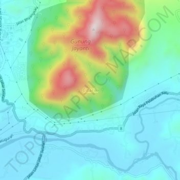
Name: Citarik topographic map, elevation, terrain.

Location: Citarik, Sukabumi, West Java, Java, Indonesia (-7.02158 106.55727 -6.98158 106.59727)

Average elevation: 148 m

Minimum elevation: 1 m

Maximum elevation: 594 m

Gear up for your next adventure:

🥾Trail Hiking Boots - Supportive boots for rough trails
🧥Waterproof Hiking Jacket - Protect yourself from rain and wind while hiking
🧴Outdoor Sunscreen - High SPF protection for high-altitude UV exposure
💧Reusable Water Bottle - Durable water bottles for hydration on trails
🧰Multitool Knife - Compact and versatile tool for outdoor use

As an Amazon Associate, this site earns from qualifying purchases at no extra cost to you.