
Make a donation
Gear up for your next adventure:
As an Amazon Associate, this site earns from qualifying purchases at no extra cost to you.
Kleinalfalterbach topographic map
Click on the map to display elevation.
Make a donation
Gear up for your next adventure:
As an Amazon Associate, this site earns from qualifying purchases at no extra cost to you.
About this map
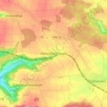
Name: Kleinalfalterbach topographic map, elevation, terrain.
Average elevation: 529 m
Minimum elevation: 452 m
Maximum elevation: 576 m
Make a donation
Gear up for your next adventure:
As an Amazon Associate, this site earns from qualifying purchases at no extra cost to you.
Other topographic maps
Click on a map to view its topography, its elevation and its terrain.
Parsberg
Deutschland > Bayern > Landkreis Neumarkt in der Oberpfalz
Die Stadt Parsberg befindet sich zwischen den Städten Regensburg und Neumarkt am Tal der Schwarzen Laber. Die Topografie der Stadt weist große Höhenunterschiede auf, und der bewegte Landschaftsraum wird als Kuppenalb bezeichnet.
Average elevation: 514 m