Geolocate

Calabuso topographic map

Click on the map to display elevation.

About this map

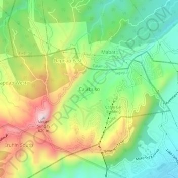
Name: Calabuso topographic map, elevation, terrain.

Location: Calabuso, Tagaytay, Cavite, Calabarzon, 4120, Philippines (14.12845 121.01262 14.16845 121.05262)

Average elevation: 413 m

Minimum elevation: 208 m

Maximum elevation: 728 m

Other topographic maps

Click on a map to view its topography, its elevation and its terrain.

People's Park in the Sky

Philippines > Cavite > Tagaytay

Average elevation: 503 m

Gear up for your next adventure:

👟Leg Gaiters - Keep debris, mud, and snow out of your boots
🧦Crew Hiking Socks - Comfortable socks for long-distance hikes
🧴Bear Spray Holster - Quick-access carry for essential Canadian wilderness safety
❄️Traction Ice Cleats - Slip-on spikes for icy trails and winter hiking
🧢Hiking Hat - Sun-protective and breathable hats for long treks

As an Amazon Associate, this site earns from qualifying purchases at no extra cost to you.