Geolocate

Zuari topographic map

Click on the map to display elevation.

About this map

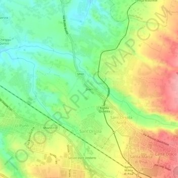
Name: Zuari topographic map, elevation, terrain.

Location: Zuari, Sassari, Sardinia, 07100, Italy (40.73873 8.51369 40.77873 8.55369)

Average elevation: 130 m

Minimum elevation: 77 m

Maximum elevation: 195 m

Other topographic maps

Click on a map to view its topography, its elevation and its terrain.

San Giovanni

Italy > Sardinia > Sassari > Sassari > Ottava

Average elevation: 82 m

Gear up for your next adventure:

🧥Waterproof Pants - Keep dry during rainy hiking conditions
💡Portable Camping Lamp - Rechargeable lamp for campsite lighting
🕶️Polarized Sunglasses - Protect your eyes with durable polarized lenses
Camping Tent - Weather-resistant tents suitable for 2 to 6 people
🛶Kayak Dry Bag - Waterproof storage for kayaking adventures

As an Amazon Associate, this site earns from qualifying purchases at no extra cost to you.