
Make a donation
Gear up for your next adventure:
As an Amazon Associate, this site earns from qualifying purchases at no extra cost to you.
Šipovo topographic map
Click on the map to display elevation.
Make a donation
Gear up for your next adventure:
As an Amazon Associate, this site earns from qualifying purchases at no extra cost to you.
Šipovo
The town lies in the northern part of the municipality, in the basin of the aforementioned rivers. 60% of the population of Šipovo lives in the town. In terms of traffic, two important roads stretch across Šipovo along the valleys of the rivers Pliva and Janj: Banjaluka-Šipovo-Kupres and Jezero-Šipovo-Glamoč. The topography of the area of Šipovo consists of the following landscape constituents.
Make a donation
Gear up for your next adventure:
As an Amazon Associate, this site earns from qualifying purchases at no extra cost to you.
About this map
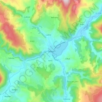
Name: Šipovo topographic map, elevation, terrain.
Average elevation: 612 m
Minimum elevation: 430 m
Maximum elevation: 1,039 m
Make a donation
Gear up for your next adventure:
As an Amazon Associate, this site earns from qualifying purchases at no extra cost to you.
Other topographic maps
Click on a map to view its topography, its elevation and its terrain.
Make a donation
Gear up for your next adventure:
As an Amazon Associate, this site earns from qualifying purchases at no extra cost to you.
Горња Драготиња / Gornja Dragotinja
Bosnia and Herzegovina > Republika Srpska > City of Prijedor
Average elevation: 253 m
Make a donation
Gear up for your next adventure:
As an Amazon Associate, this site earns from qualifying purchases at no extra cost to you.
Krupa na Vrbasu
Bosnia and Herzegovina > Republika Srpska > City of Banja Luka
Average elevation: 648 m
Make a donation
Gear up for your next adventure:
As an Amazon Associate, this site earns from qualifying purchases at no extra cost to you.
Make a donation
Gear up for your next adventure:
As an Amazon Associate, this site earns from qualifying purchases at no extra cost to you.
Jahorina
Bosnia and Herzegovina > Republika Srpska > City of Istočno Sarajevo
Average elevation: 1,278 m