Geolocate

Logroño topographic map

Click on the map to display elevation.

About this map

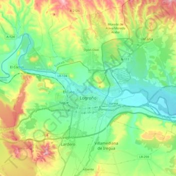
Name: Logroño topographic map, elevation, terrain.

Location: Logroño, Rioja, Spain (42.42885 -2.54227 42.51992 -2.34197)

Average elevation: 448 m

Minimum elevation: 352 m

Maximum elevation: 646 m

Gear up for your next adventure:

🔭Compact Monocular - One-handed bird watching and trail spotting
🥽Outdoor Goggles - Protective eyewear for outdoor activities
🧦Merino Wool Socks - Moisture-wicking comfort for long-distance hiking
🧥Waterproof Pants - Keep dry during rainy hiking conditions
🥘Camping Cookware Set - Compact nesting pots and pans for trail cooking

As an Amazon Associate, this site earns from qualifying purchases at no extra cost to you.