Geolocate

Chiddingstone topographic map

Click on the map to display elevation.

About this map

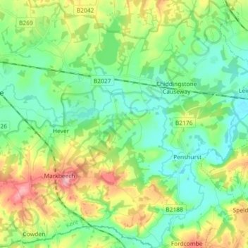
Name: Chiddingstone topographic map, elevation, terrain.

Location: Chiddingstone, Sevenoaks, Kent, England, United Kingdom (51.13943 0.11802 51.22942 0.18101)

Average elevation: 64 m

Minimum elevation: 24 m

Maximum elevation: 149 m

Other topographic maps

Click on a map to view its topography, its elevation and its terrain.

The Masthead

United Kingdom > England > Kent > Sevenoaks

Average elevation: 149 m

Gear up for your next adventure:

🧥Insulated Jacket - Keep warm in cold outdoor conditions
💡LED Camping Lantern - Illuminate your campsite with long-lasting lanterns
🧭Orienteering Kit - Tools for map reading and navigation in the wild
🧢Sun Protection Cap - Breathable cap to protect from sun exposure
🧦Thermal Socks - Warm socks for winter hiking or camping

As an Amazon Associate, this site earns from qualifying purchases at no extra cost to you.