
Make a donation
Gear up for your next adventure:
As an Amazon Associate, this site earns from qualifying purchases at no extra cost to you.
Hatton topographic map
Click on the map to display elevation.
Make a donation
Gear up for your next adventure:
As an Amazon Associate, this site earns from qualifying purchases at no extra cost to you.
Hatton
Hatton is located approximately 112 km (70 mi) southeast of Colombo and 72 km (45 mi) south of Kandy, at an elevation of 1,271 m (4,170 ft) above sea level.
Make a donation
Gear up for your next adventure:
As an Amazon Associate, this site earns from qualifying purchases at no extra cost to you.
About this map
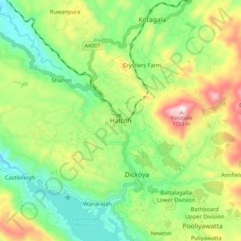
Name: Hatton topographic map, elevation, terrain.
Average elevation: 1,290 m
Minimum elevation: 1,039 m
Maximum elevation: 1,714 m
Make a donation
Gear up for your next adventure:
As an Amazon Associate, this site earns from qualifying purchases at no extra cost to you.
Other topographic maps
Click on a map to view its topography, its elevation and its terrain.
Make a donation
Gear up for your next adventure:
As an Amazon Associate, this site earns from qualifying purchases at no extra cost to you.
Horton Plains National Park
Horton Plains National Park (Sinhala: හෝර්ටන් තැන්න ජාතික උද්යානය, romanized: Hortan Thanna Jathika Udyanaya) is a national park in the central highlands of Sri Lanka that was designated in 1988. It is located at an elevation of 2,100–2,300 m (6,900–7,500…
Average elevation: 2,010 m
Horton Plains National Park
Horton Plains National Park (Sinhala: හෝර්ටන් තැන්න ජාතික උද්යානය, romanized: Hortan Thanna Jathika Udyanaya) is a national park in the central highlands of Sri Lanka that was designated in 1988. It covers an area of 31km² and borders Thotupalakanda Nature…
Average elevation: 2,010 m
Make a donation
Gear up for your next adventure:
As an Amazon Associate, this site earns from qualifying purchases at no extra cost to you.