
Make a donation
Gear up for your next adventure:
As an Amazon Associate, this site earns from qualifying purchases at no extra cost to you.
Nordhelle topographic map
Click on the map to display elevation.
Make a donation
Gear up for your next adventure:
As an Amazon Associate, this site earns from qualifying purchases at no extra cost to you.
Nordhelle
Die im westlichen Sauerland gelegene Nordhelle erhebt sich etwa im Zentrum des Ebbegebirges im Naturpark Sauerland-Rothaargebirge (ehemals Naturpark Ebbegebirge) im Gemeindegebiet von Herscheid und im Stadtgebiet von Meinerzhagen. Ihr Gipfel liegt etwa 200 m nördlich der auf maximal rund 652 m Höhe führenden Grenze von Herscheid mit dem Ortsteil Reblin im Norden und Meinerzhagen mit dem Stadtteil Valbert im Süden. Während die Gipfelregion und die nördlichen Bergteile zur Gemarkung Herscheid gehören, zählen die südlichen zur Gemarkung Valbert. Ostsüdöstlicher „Vorberg“ der Nordhelle ist der Waldberg (ca. 638 m) und südsüdwestlicher Nachbar die Große Hahn (632,6 m).
Make a donation
Gear up for your next adventure:
As an Amazon Associate, this site earns from qualifying purchases at no extra cost to you.
About this map
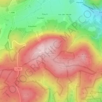
Name: Nordhelle topographic map, elevation, terrain.
Average elevation: 547 m
Minimum elevation: 393 m
Maximum elevation: 664 m
Make a donation
Gear up for your next adventure:
As an Amazon Associate, this site earns from qualifying purchases at no extra cost to you.