Geolocate

Luinab topographic map

Click on the map to display elevation.

About this map

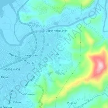
Name: Luinab topographic map, elevation, terrain.

Location: Luinab, Iligan, Northern Mindanao, 9200, Philippines (8.22705 124.24797 8.26705 124.28797)

Average elevation: 48 m

Minimum elevation: -1 m

Maximum elevation: 292 m

Other topographic maps

Click on a map to view its topography, its elevation and its terrain.

Digkila-an

Philippines > Iligan

Average elevation: 151 m

Agus River

Philippines > Iligan > Ditucalan > Upper Taytay

Average elevation: 234 m

Gear up for your next adventure:

Camping Tent - Weather-resistant tents suitable for 2 to 6 people
🧢Sun Protection Cap - Breathable cap to protect from sun exposure
🚲Heavy Duty Bike Lock - Secure your bike at the trailhead or during stops
🥤Collapsible Travel Cup - Saves space and weight in your mess kit
🕶️Polarized Sunglasses - Reduces glare from snow and water at high elevations

As an Amazon Associate, this site earns from qualifying purchases at no extra cost to you.