Geolocate

Bogota topographic map

Click on the map to display elevation.

About this map

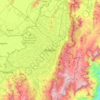
Name: Bogota topographic map, elevation, terrain.

Location: Bogota, Distrito Capital de Bogotá, 110321, Colombia (4.43808 -74.23604 4.75808 -73.91604)

Average elevation: 2,766 m

Minimum elevation: 1,657 m

Maximum elevation: 3,696 m

Gear up for your next adventure:

🎒Hiking Daypack - Lightweight and durable backpacks for day trips and excursions
🥾Approach Boots - Comfortable boots for hiking and climbing approaches
👟Leg Gaiters - Keep debris, mud, and snow out of your boots
🥾Trail Hiking Shoes - Durable shoes designed for rugged trails
👟Trail Running Shoes - Agile footwear for fast-paced topographic exploration

As an Amazon Associate, this site earns from qualifying purchases at no extra cost to you.