
Central topographic map
Click on the map to display elevation.
About this map
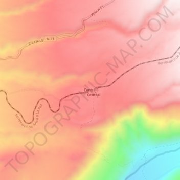
Name: Central topographic map, elevation, terrain.
Average elevation: 1,409 m
Minimum elevation: 939 m
Maximum elevation: 1,611 m
Other topographic maps
Click on a map to view its topography, its elevation and its terrain.
Valle de Lluta
Chile > Región de Arica y Parinacota > Provincia de Arica > Arica
Average elevation: 829 m
Monumento Natural Picaflor de Arica
Chile > Región de Arica y Parinacota > Provincia de Arica > Arica
Average elevation: 404 m
Playa Chinchorro
Chile > Región de Arica y Parinacota > Provincia de Arica > Arica > Chinchorro
Average elevation: 14 m
Playa Chinchorro
Chile > Región de Arica y Parinacota > Provincia de Arica > Arica > Chinchorro
Average elevation: 14 m