
Thank you for supporting this site ❤️
Make a donation
Make a donation
Gear up for your next adventure:
As an Amazon Associate, this site earns from qualifying purchases at no extra cost to you.
Mascouche topographic map
Click on the map to display elevation.
Thank you for supporting this site ❤️
Make a donation
Make a donation
Gear up for your next adventure:
As an Amazon Associate, this site earns from qualifying purchases at no extra cost to you.
About this map
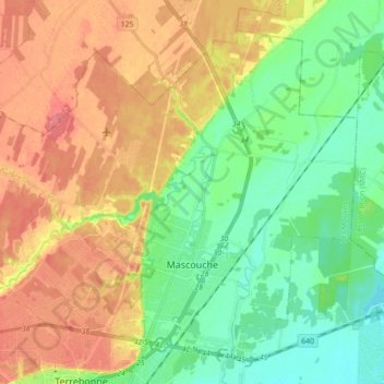
Name: Mascouche topographic map, elevation, terrain.
Location: Mascouche, Les Moulins, Lanaudière, Quebec, Canada (45.71633 -73.70105 45.82039 -73.52494)
Average elevation: 36 m
Minimum elevation: 8 m
Maximum elevation: 69 m
Les Moulins trails, hiking, mountain biking, running and outdoor activities
Thank you for supporting this site ❤️
Make a donation
Make a donation
Gear up for your next adventure:
As an Amazon Associate, this site earns from qualifying purchases at no extra cost to you.
Other topographic maps
Click on a map to view its topography, its elevation and its terrain.