Geolocate

Meißner topographic map

Click on the map to display elevation.

About this map

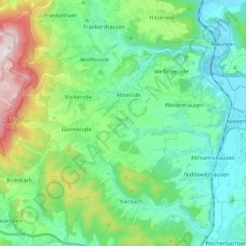
Name: Meißner topographic map, elevation, terrain.

Location: Meißner, Werra-Meißner-Kreis, Hesse, 37290, Germany (51.16866 9.83960 51.22861 9.98942)

Average elevation: 316 m

Minimum elevation: 148 m

Maximum elevation: 761 m

Other topographic maps

Click on a map to view its topography, its elevation and its terrain.

Gear up for your next adventure:

🕶️Polarized Sunglasses - Protect your eyes with durable polarized lenses
🧢Beanie Hat - Keep your head warm in cold weather
💧Collapsible Water Bottle - Space-saving water bottle for outdoor activities
Lightweight Camping Tent - Portable shelter optimized for Canadian backcountry camping
🧥Waterproof Jacket - Lightweight rain jackets for hiking and outdoor activities

As an Amazon Associate, this site earns from qualifying purchases at no extra cost to you.