
Kapuskasing topographic map
Click on the map to display elevation.
Kapuskasing
Kapuskasing lies in the heart of the Great Clay Belt. The topography of the region is very flat, dotted with numerous small lakes and muskeg bogs. Also in the heart of Canada's boreal forest, the region is drained by rivers running north to James Bay. The district is heavily forested, mostly by thick stands of black spruce that have commercial value as pulpwood.
About this map
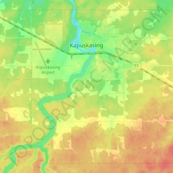
Name: Kapuskasing topographic map, elevation, terrain.
Average elevation: 227 m
Minimum elevation: 202 m
Maximum elevation: 249 m
Cochrane District trails, hiking, mountain biking, running and outdoor activities
Other topographic maps
Click on a map to view its topography, its elevation and its terrain.
Painkiller Lake
Canada > Ontario > Cochrane District > Black River-Matheson Township
Average elevation: 302 m
Borgford Lake
Canada > Ontario > Cochrane District > Black River-Matheson Township
Average elevation: 346 m
Arrow Lake
Canada > Ontario > Cochrane District > Unorganized South West Cochrane
Average elevation: 297 m
Watersnake Lake
Canada > Ontario > Cochrane District > Fauquier-Strickland Township
Average elevation: 233 m
Kabinakagami River
Canada > Ontario > Cochrane District > Unorganized North Cochrane
Average elevation: 250 m
Watabeag River
Canada > Ontario > Cochrane District > Black River-Matheson Township
Average elevation: 261 m
Ptarmigan Lake
Canada > Ontario > Cochrane District > Unorganized North Cochrane
Average elevation: 225 m
Joseph Lake
Canada > Ontario > Cochrane District > Unorganized North Cochrane
Average elevation: 271 m
Moose Factory Island
Canada > Ontario > Cochrane District > Unorganized North Cochrane
Average elevation: 4 m
Wadsworth Lake
Canada > Ontario > Cochrane District > Unorganized North Cochrane
Average elevation: 323 m
Ghost River
Canada > Ontario > Cochrane District > Unorganized North Cochrane
Average elevation: 287 m
Moose Factory Island
Canada > Ontario > Cochrane District > Unorganized North Cochrane
Average elevation: 4 m
Big Cedar Creek
Canada > Ontario > Cochrane District > Unorganized North Cochrane
Average elevation: 49 m