
Thank you for supporting this site ❤️
Make a donation
Make a donation
Gear up for your next adventure:
As an Amazon Associate, this site earns from qualifying purchases at no extra cost to you.
Cordova topographic map
Click on the map to display elevation.
Thank you for supporting this site ❤️
Make a donation
Make a donation
Gear up for your next adventure:
As an Amazon Associate, this site earns from qualifying purchases at no extra cost to you.
About this map
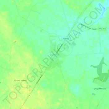
Name: Cordova topographic map, elevation, terrain.
Location: Cordova, Talbot County, Maryland, 21625, United States (38.85567 -76.01605 38.89567 -75.97605)
Average elevation: 17 m
Minimum elevation: 8 m
Maximum elevation: 25 m
Thank you for supporting this site ❤️
Make a donation
Make a donation
Gear up for your next adventure:
As an Amazon Associate, this site earns from qualifying purchases at no extra cost to you.
Other topographic maps
Click on a map to view its topography, its elevation and its terrain.
Choptank Wetlands - Kings Creek
United States > Maryland > Talbot County > Kingston Landing
Average elevation: 4 m