
Make a donation
Gear up for your next adventure:
As an Amazon Associate, this site earns from qualifying purchases at no extra cost to you.
Kohistan topographic map
Click on the map to display elevation.
Make a donation
Gear up for your next adventure:
As an Amazon Associate, this site earns from qualifying purchases at no extra cost to you.
Kohistan
Kohistan district is the southernmost district in Faryab Province. Its population is 53,100 (2010). The district center is Qal'a 35°22′52″N 64°45′22″E / 35.3811°N 64.7561°E / 35.3811; 64.7561, 1909 m altitude.
Make a donation
Gear up for your next adventure:
As an Amazon Associate, this site earns from qualifying purchases at no extra cost to you.
About this map
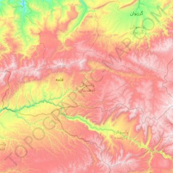
Name: Kohistan topographic map, elevation, terrain.
Location: Kohistan, Faryab Province, Afghanistan (35.16297 64.40751 35.52815 65.46123)
Average elevation: 2,269 m
Minimum elevation: 1,054 m
Maximum elevation: 3,448 m
Make a donation
Gear up for your next adventure:
As an Amazon Associate, this site earns from qualifying purchases at no extra cost to you.
Other topographic maps
Click on a map to view its topography, its elevation and its terrain.