
Make a donation
Gear up for your next adventure:
As an Amazon Associate, this site earns from qualifying purchases at no extra cost to you.
Changhua County topographic map
Click on the map to display elevation.
Make a donation
Gear up for your next adventure:
As an Amazon Associate, this site earns from qualifying purchases at no extra cost to you.
Changhua County
The county's total area is 1,074 km2 (415 sq mi), being Taiwan's smallest county. It owns a 60 km (37 mi) of coastline. The landscape of Changhua can be roughly divided into two parts, one being the western flat land, and the other being the Changhua Plain. This two combines measures up to 88% of Changhua county's total area. The highest elevation in Changhua is "Hen Shan", at 443 m (1,453 ft).
Make a donation
Gear up for your next adventure:
As an Amazon Associate, this site earns from qualifying purchases at no extra cost to you.
About this map
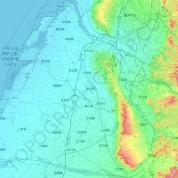
Name: Changhua County topographic map, elevation, terrain.
Location: Changhua County, Taiwan Province, Taiwan (23.78561 120.22036 24.20718 120.68395)
Average elevation: 77 m
Minimum elevation: -2 m
Maximum elevation: 615 m
Make a donation
Gear up for your next adventure:
As an Amazon Associate, this site earns from qualifying purchases at no extra cost to you.
Other topographic maps
Click on a map to view its topography, its elevation and its terrain.