Geolocate

Hope Island topographic map

Click on the map to display elevation.

About this map

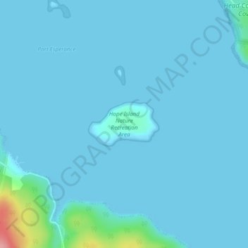
Name: Hope Island topographic map, elevation, terrain.

Location: Hope Island, Huon Valley, Tasmania, Australia (-43.33926 147.03715 -43.33460 147.04745)

Average elevation: 7 m

Minimum elevation: -1 m

Maximum elevation: 122 m

Other topographic maps

Click on a map to view its topography, its elevation and its terrain.

Frog Hill

Australia > Tasmania

Average elevation: 875 m

Mount Kate

Australia > Tasmania

Average elevation: 995 m

Tasman Peninsula

Australia > Tasmania > Tasman > Fortescue

Average elevation: 167 m

Mount Jukes

Australia > Tasmania

Average elevation: 773 m

Ulverstone

Australia > Tasmania > Ulverstone

Average elevation: 37 m

Bullock Hill

Australia > Tasmania > Grove

Average elevation: 147 m

Highland Waters

Australia > Tasmania > London Lakes

Average elevation: 759 m

Stillwater Hill

Australia > Tasmania

Average elevation: 353 m

Legges Tor

Australia > Tasmania

Average elevation: 1,457 m

Rowlands Hill

Australia > Tasmania

Average elevation: 388 m

Recherche Bay

Australia > Tasmania

Average elevation: 10 m

Bastyan Dam

Australia > Tasmania > Tullah

Average elevation: 233 m

Gear up for your next adventure:

🧥Waterproof Pants - Keep dry during rainy hiking conditions
🧤Insulated Winter Gloves - Heavy-duty protection for sub-zero Canadian adventures
🧥Fleece Jacket - Warm and lightweight jacket for layering
🧦Hiking Liner Socks - Thin base layer to prevent friction and blisters
🗺️Topographic Maps - Detailed maps to explore trails, mountains, and wilderness areas

As an Amazon Associate, this site earns from qualifying purchases at no extra cost to you.