Bishop topographic map
Interactive map
Click on the map to display elevation.
About this map
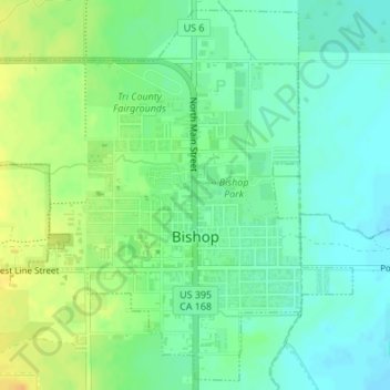
Name: Bishop topographic map, elevation, terrain.
Location: Bishop, Inyo County, California, United States (37.35367 -118.41384 37.37934 -118.38154)
Average elevation: 1,265 m
Minimum elevation: 1,253 m
Maximum elevation: 1,282 m
Bishop (formerly Bishop Creek) is a city in California, United States. It is the largest populated place and only incorporated city in Inyo County. Bishop is located near the northern end of the Owens Valley, at an elevation of 4,150 feet (1,260 m). The city was named after Bishop Creek, flowing out of the Sierra Nevada; the creek was named after Samuel Addison Bishop, a settler in the Owens Valley. Bishop is a commercial and residential center, while many vacation destinations and tourist attractions in the Sierra Nevada are located nearby.
Other topographic maps
Click on a map to view its topography, its elevation and its terrain.
Devils Golf Course
United States > California > Inyo County
Devils Golf Course, Devil's Golf Course Road, Inyo County, California, United States
Average elevation: -80 m
Furnace Creek
United States > California > Inyo County
Furnace Creek, Inyo County, California, 92328, United States
Average elevation: -27 m
Death Valley Playa
United States > California > Inyo County
Death Valley Playa, Inyo County, California, United States
Average elevation: 881 m
Margaret Lake
United States > California > Inyo County
Margaret Lake, Inyo County, California, United States
Average elevation: 3,467 m
Pearsonville
United States > California > Inyo County
Pearsonville, Inyo County, California, United States
Average elevation: 796 m
Cirque Peak
United States > California > Inyo County
Cirque Peak, Inyo County, California, United States
Average elevation: 3,600 m
Lone Pine
United States > California > Inyo County
Lone Pine, Inyo County, California, 93545, United States
Average elevation: 1,298 m
Mount Whitney
United States > California > Inyo County
Mount Whitney, Inyo County, CAL Fire Southern Region, California, United States
Average elevation: 3,903 m
Badwater
United States > California > Inyo County
Badwater, Inyo County, California, United States
Average elevation: 161 m