
Make a donation
Gear up for your next adventure:
As an Amazon Associate, this site earns from qualifying purchases at no extra cost to you.
Ovada topographic map
Click on the map to display elevation.
Make a donation
Gear up for your next adventure:
As an Amazon Associate, this site earns from qualifying purchases at no extra cost to you.
Ovada
Die Gemeinde Ovada liegt 35 km südlich der Provinzhauptstadt Alessandria auf einer Höhe von 186 m s.l.m. Sie liegt genau am Zusammenfluss der Stura in den Orba. Das Gemeindegebiet umfasst mit den Fraktionen Borgo, Costa, Gnocchetto, Grillano, Guardia und San Lorenzo eine Fläche von 35,37 km².
Make a donation
Gear up for your next adventure:
As an Amazon Associate, this site earns from qualifying purchases at no extra cost to you.
About this map
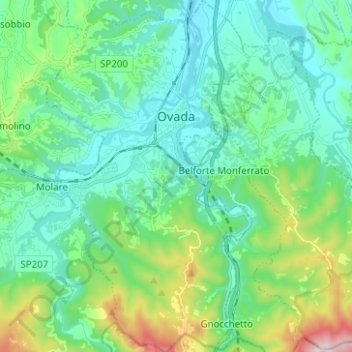
Name: Ovada topographic map, elevation, terrain.
Location: Ovada, Alessandria, Piemont, Italien (44.57863 8.59919 44.66756 8.67227)
Average elevation: 302 m
Minimum elevation: 151 m
Maximum elevation: 835 m
Make a donation
Gear up for your next adventure:
As an Amazon Associate, this site earns from qualifying purchases at no extra cost to you.
Other topographic maps
Click on a map to view its topography, its elevation and its terrain.
Make a donation
Gear up for your next adventure:
As an Amazon Associate, this site earns from qualifying purchases at no extra cost to you.