Geolocate

Carters Lake topographic map

Click on the map to display elevation.

About this map

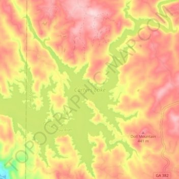
Name: Carters Lake topographic map, elevation, terrain.

Location: Carters Lake, Gilmer County, Georgia, United States (34.58811 -84.67356 34.65417 -84.60089)

Average elevation: 370 m

Minimum elevation: 210 m

Maximum elevation: 470 m

Other topographic maps

Click on a map to view its topography, its elevation and its terrain.

Dyke

United States > Georgia > Gilmer County

Average elevation: 508 m

Big Bald Mountain

United States > Georgia > Gilmer County

Average elevation: 1,021 m

Yukon

United States > Georgia > Gilmer County

Average elevation: 475 m

Cherry Log

United States > Georgia > Gilmer County

Average elevation: 522 m

Lucius

United States > Georgia > Gilmer County

Average elevation: 535 m

White Cliffs

United States > Georgia > Gilmer County

Average elevation: 833 m

Gear up for your next adventure:

🥾Light Trekking Boots - Supportive boots for multi-day treks
🌬️Windproof Camp Stove - Efficient cooking even on exposed mountain peaks
🧤Thermal Hiking Gloves - Grip-enhanced gloves for cold-weather altitude trekking
🔭Outdoor Binoculars - Lightweight binoculars for birdwatching and hiking
🦟Insect Repellent - Keep mosquitoes and black flies away in wooded areas

As an Amazon Associate, this site earns from qualifying purchases at no extra cost to you.