
Make a donation
Gear up for your next adventure:
As an Amazon Associate, this site earns from qualifying purchases at no extra cost to you.
Pine Grove topographic map
Click on the map to display elevation.
Make a donation
Gear up for your next adventure:
As an Amazon Associate, this site earns from qualifying purchases at no extra cost to you.
About this map
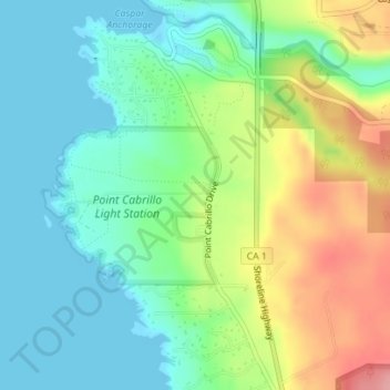
Name: Pine Grove topographic map, elevation, terrain.
Average elevation: 40 m
Minimum elevation: -1 m
Maximum elevation: 123 m
Make a donation
Gear up for your next adventure:
As an Amazon Associate, this site earns from qualifying purchases at no extra cost to you.
Other topographic maps
Click on a map to view its topography, its elevation and its terrain.
Redwood Valley
United States > California > Mendocino County
Redwood Valley (formerly Basil) is a census-designated place (CDP) in Mendocino County, California, United States. It is located 9 miles (14 km) north of Ukiah, the county seat, at an elevation of 722 feet (220 m), and comprises the northern portion of the Ukiah Valley. It is about 15 miles (24 km) southeast…
Average elevation: 246 m