
Make a donation
Gear up for your next adventure:
As an Amazon Associate, this site earns from qualifying purchases at no extra cost to you.
Boitzum topographic map
Click on the map to display elevation.
Make a donation
Gear up for your next adventure:
As an Amazon Associate, this site earns from qualifying purchases at no extra cost to you.
Boitzum
Das Dorf liegt zwischen den früheren Klöstern Wülfinghausen und Wittenburg. an der West- und Nordseite eines kleinen Höhenzuges, der Finie, die sich von Boitzum über Wittenburg bis Sorsum und in die Wülfinger Feldmark erstreckt. Ihre höchste Erhebung ist 169 m, innerhalb der Boitzumer Feldmark südlich von Boitzum ist die Finie 146,9 m hoch. Der Mittelpunkt von Boitzum, der Thie, liegt 105 m über dem Meeresspiegel.
Make a donation
Gear up for your next adventure:
As an Amazon Associate, this site earns from qualifying purchases at no extra cost to you.
About this map
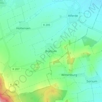
Name: Boitzum topographic map, elevation, terrain.
Average elevation: 113 m
Minimum elevation: 73 m
Maximum elevation: 246 m
Make a donation
Gear up for your next adventure:
As an Amazon Associate, this site earns from qualifying purchases at no extra cost to you.
Other topographic maps
Click on a map to view its topography, its elevation and its terrain.
Make a donation
Gear up for your next adventure:
As an Amazon Associate, this site earns from qualifying purchases at no extra cost to you.