Geolocate

Appelscha topographic map

Click on the map to display elevation.

About this map

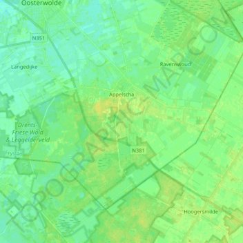
Name: Appelscha topographic map, elevation, terrain.

Location: Appelscha, Ooststellingwerf, Frisia, Netherlands (52.90636 6.26599 52.97659 6.42761)

Average elevation: 10 m

Minimum elevation: 4 m

Maximum elevation: 18 m

Other topographic maps

Click on a map to view its topography, its elevation and its terrain.

Vierhuizen

Netherlands > Frisia > Allingawier

Average elevation: -2 m

Oost-Vlieland

Netherlands > Frisia

Average elevation: 2 m

Kooiplaats

Netherlands > Frisia > Buren

Average elevation: 1 m

Loënga

Netherlands > Frisia > Loënga

Average elevation: 0 m

Leeuwarden

Netherlands > Frisia > Leeuwarden

Average elevation: 0 m

Gear up for your next adventure:

🕯️Camping Lantern - Illuminates your entire campsite with high-efficiency LEDs
🥾Trail Running Shoes - Lightweight and durable shoes for trail running
🏕️Camping Hammock - Integrated protection for sleeping between trees
🛌Insulated Sleeping Pad - Critical thermal barrier between you and the cold ground
🧭Orienteering Kit - Tools for map reading and navigation in the wild

As an Amazon Associate, this site earns from qualifying purchases at no extra cost to you.