Geolocate

Hagerman Lake topographic map

Click on the map to display elevation.

About this map

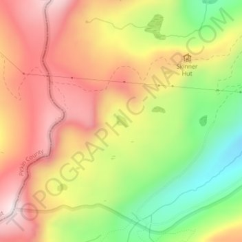
Name: Hagerman Lake topographic map, elevation, terrain.

Location: Hagerman Lake, Lake County, Colorado, United States (39.25825 -106.47353 39.25963 -106.47175)

Average elevation: 3,484 m

Minimum elevation: 3,163 m

Maximum elevation: 3,758 m

Other topographic maps

Click on a map to view its topography, its elevation and its terrain.

Lake Creek

United States > Colorado > Lake County

Average elevation: 3,293 m

Mount Evans

United States > Colorado > Lake County

Average elevation: 3,828 m

Gear up for your next adventure:

🚲Heavy Duty Bike Lock - Secure your bike at the trailhead or during stops
🎒Fully Waterproof Backpack - Total protection for photography gear and electronics
🚲Handlebar Phone Mount - View topographic-map.com live while cycling
🔭Compact Binoculars - Lightweight optics for scouting trails and wildlife
🧦Hiking Liner Socks - Thin base layer to prevent friction and blisters

As an Amazon Associate, this site earns from qualifying purchases at no extra cost to you.