Geolocate

Newbury topographic map

Click on the map to display elevation.

Newbury

Elevations vary from a minimum of 72m above mean sea level to 122m at Wash Common. Elevations reach 150-200m in the directly adjoining hills.

About this map

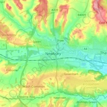
Name: Newbury topographic map, elevation, terrain.

Location: Newbury, West Berkshire, South East, England, RG14 1DJ, United Kingdom (51.36201 -1.36364 51.44201 -1.28364)

Average elevation: 102 m

Minimum elevation: 65 m

Maximum elevation: 162 m

Gear up for your next adventure:

🥾Hiking Leggings - Comfortable leggings for outdoor activities
🧤Thermal Hiking Gloves - Grip-enhanced gloves for cold-weather altitude trekking
🥾Trekking Boots - Durable boots for long-distance trekking
🧥Ultralight Puffy Jacket - Maximum warmth that packs down to the size of an orange
💧Collapsible Water Bottle - Space-saving water bottle for outdoor activities

As an Amazon Associate, this site earns from qualifying purchases at no extra cost to you.