Geolocate

Armo topographic map

Click on the map to display elevation.

About this map

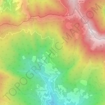
Name: Armo topographic map, elevation, terrain.

Location: Armo, Imperia, Liguria, Italy (44.07948 7.88242 44.11182 7.93463)

Average elevation: 942 m

Minimum elevation: 418 m

Maximum elevation: 1,487 m

Gear up for your next adventure:

🧶550 Survival Paracord - Versatile utility cord for emergency repairs and rigging
🧥Ultralight Puffy Jacket - Maximum warmth that packs down to the size of an orange
🥾Waterproof Hiking Boots - Boots keeping your feet dry in wet conditions
🥾Lightweight Hiking Boots - Boots for comfort and mobility on long hikes
Backpacking Tent - Lightweight tent for long-distance hiking trips

As an Amazon Associate, this site earns from qualifying purchases at no extra cost to you.