Geolocate

Koblenz topographic map

Click on the map to display elevation.

About this map

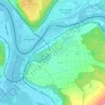
Name: Koblenz topographic map, elevation, terrain.

Location: Koblenz, Bezirk Zurzach, Aargau, 5322, Switzerland (47.59538 8.22095 47.61533 8.26390)

Average elevation: 348 m

Minimum elevation: 311 m

Maximum elevation: 502 m

Gear up for your next adventure:

🛶Kayak Accessories - Essential gear for safe and fun kayaking adventures
🚲Handlebar Phone Mount - View topographic-map.com live while cycling
🛏️Sleeping Bag - Warm and compact sleeping bags for outdoor camping
🧦Crew Hiking Socks - Comfortable socks for long-distance hikes
🪜Heavy Duty Carabiners - Multi-use clips for securing gear to your backpack

As an Amazon Associate, this site earns from qualifying purchases at no extra cost to you.