
Make a donation
Gear up for your next adventure:
As an Amazon Associate, this site earns from qualifying purchases at no extra cost to you.
Moultonborough topographic map
Click on the map to display elevation.
Make a donation
Gear up for your next adventure:
As an Amazon Associate, this site earns from qualifying purchases at no extra cost to you.
Moultonborough
According to the United States Census Bureau, the town has a total area of 75.1 square miles (194.5 km2), of which 59.7 square miles (154.6 km2) are land and 15.4 square miles (39.9 km2) are water, comprising 20.50% of the town. A large portion of the town is located along Lake Winnipesaukee, the largest lake in New Hampshire. Moultonborough Bay, an 8-mile-long (13 km) arm of the lake, extends from the southern corner of the town towards the center of the town. Moultonborough Neck forms a peninsula between Moultonborough Bay and Center Harbor to the southwest. Long Island, the largest island in Lake Winnipesaukee, is connected to Moultonborough Neck by a bridge. The community of Suissevale, a census-designated place, occupies part of the northeast shore of Moultonborough Bay. Inland from Winnipesaukee, Lake Kanasatka is in the west part of the town. Red Hill, elevation 2,029 feet (618 m), is in the northwest. Mount Shaw, elevation 2,990 feet (911 m), part of the Ossipee Mountains and the highest point in Moultonborough, is in the east.
Make a donation
Gear up for your next adventure:
As an Amazon Associate, this site earns from qualifying purchases at no extra cost to you.
About this map
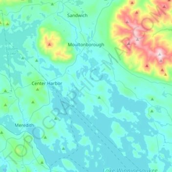
Name: Moultonborough topographic map, elevation, terrain.
Location: Moultonborough, Carroll County, New Hampshire, United States (43.62682 -71.53231 43.78282 -71.24590)
Average elevation: 244 m
Minimum elevation: 143 m
Maximum elevation: 896 m
Make a donation
Gear up for your next adventure:
As an Amazon Associate, this site earns from qualifying purchases at no extra cost to you.
Other topographic maps
Click on a map to view its topography, its elevation and its terrain.
Castle in the Clouds
United States > New Hampshire > Carroll County > Moultonborough
Average elevation: 363 m
Winnipesaukee
United States > New Hampshire > Carroll County > Moultonborough
Average elevation: 161 m
Make a donation
Gear up for your next adventure:
As an Amazon Associate, this site earns from qualifying purchases at no extra cost to you.
Make a donation
Gear up for your next adventure:
As an Amazon Associate, this site earns from qualifying purchases at no extra cost to you.
Little Bear Island
United States > New Hampshire > Carroll County > Tuftonboro
Average elevation: 160 m
Black Cat Island
United States > New Hampshire > Carroll County > Moultonborough
Average elevation: 156 m
Nineacre Island
United States > New Hampshire > Carroll County > Moultonborough
Average elevation: 158 m
Make a donation
Gear up for your next adventure:
As an Amazon Associate, this site earns from qualifying purchases at no extra cost to you.
Whortleberry Island
United States > New Hampshire > Carroll County > Tuftonboro > Chase Point
Average elevation: 156 m
Cow Island
United States > New Hampshire > Carroll County > Tuftonboro > Fox Point
Average elevation: 162 m
Make a donation
Gear up for your next adventure:
As an Amazon Associate, this site earns from qualifying purchases at no extra cost to you.
Make a donation
Gear up for your next adventure:
As an Amazon Associate, this site earns from qualifying purchases at no extra cost to you.
Mount Roberts
United States > New Hampshire > Carroll County > Moultonborough
Average elevation: 611 m
Make a donation
Gear up for your next adventure:
As an Amazon Associate, this site earns from qualifying purchases at no extra cost to you.
Winnipesaukee
United States > New Hampshire > Carroll County > Moultonborough
Average elevation: 161 m
Mirror Lake
United States > New Hampshire > Carroll County > Tuftonboro > Mirror Lake
Average elevation: 169 m
Whortleberry Island
United States > New Hampshire > Carroll County > Tuftonboro > Chase Point
Average elevation: 156 m
Make a donation
Gear up for your next adventure:
As an Amazon Associate, this site earns from qualifying purchases at no extra cost to you.
Albany
United States > New Hampshire > Carroll County > Albany
According to the United States Census Bureau, the town has a total area of 75.8 square miles (196.2 km2), of which 75.1 square miles (194.6 km2) are land and 0.58 square miles (1.5 km2) are water, comprising 0.79% of the town. It is drained by the Swift River in the north and the Chocorua River in the south.…
Average elevation: 276 m
Make a donation
Gear up for your next adventure:
As an Amazon Associate, this site earns from qualifying purchases at no extra cost to you.