Geolocate

Zimapán topographic map

Click on the map to display elevation.

About this map

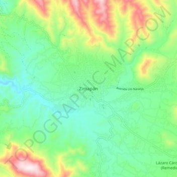
Name: Zimapán topographic map, elevation, terrain.

Location: Zimapán, Hidalgo, Mexico (20.69694 -99.42194 20.77694 -99.34194)

Average elevation: 1,851 m

Minimum elevation: 1,622 m

Maximum elevation: 2,354 m

Gear up for your next adventure:

🐕Hiking Dog Pack - Let your canine companion carry their own water and food
🧥Softshell Jacket - Windproof and breathable jacket for hiking
🌬️Windproof Camp Stove - Efficient cooking even on exposed mountain peaks
🛶Kayak Dry Bag - Waterproof storage for kayaking adventures
🔦LED Flashlight - Powerful and long-lasting flashlight for camping and emergencies

As an Amazon Associate, this site earns from qualifying purchases at no extra cost to you.