
Make a donation
Gear up for your next adventure:
As an Amazon Associate, this site earns from qualifying purchases at no extra cost to you.
Stanstead (Ville) topographic map
Click on the map to display elevation.
Make a donation
Gear up for your next adventure:
As an Amazon Associate, this site earns from qualifying purchases at no extra cost to you.
About this map
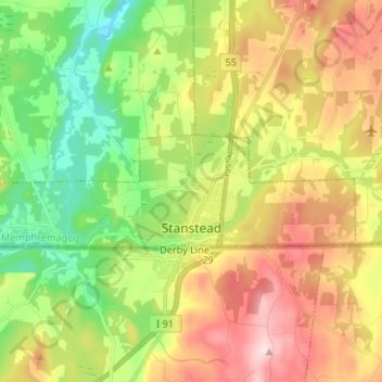
Name: Stanstead (Ville) topographic map, elevation, terrain.
Location: Stanstead (Ville), Memphrémagog, Estrie, Quebec, Canada (45.00562 -72.17274 45.03342 -72.04037)
Average elevation: 325 m
Minimum elevation: 173 m
Maximum elevation: 523 m
Memphrémagog trails, hiking, mountain biking, running and outdoor activities
Make a donation
Gear up for your next adventure:
As an Amazon Associate, this site earns from qualifying purchases at no extra cost to you.
Other topographic maps
Click on a map to view its topography, its elevation and its terrain.
Scouts Canada - Lake Lovering Scouts Reserve
Canada > Quebec > Memphrémagog > Magog
Average elevation: 260 m
Make a donation
Gear up for your next adventure:
As an Amazon Associate, this site earns from qualifying purchases at no extra cost to you.
Make a donation
Gear up for your next adventure:
As an Amazon Associate, this site earns from qualifying purchases at no extra cost to you.