Geolocate

Marion topographic map

Click on the map to display elevation.

About this map

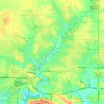
Name: Marion topographic map, elevation, terrain.

Location: Marion, Linn County, Iowa, 52302, United States (42.00933 -91.63362 42.08661 -91.52537)

Average elevation: 256 m

Minimum elevation: 231 m

Maximum elevation: 288 m

Other topographic maps

Click on a map to view its topography, its elevation and its terrain.

New Buffalo

United States > Iowa > Linn County > Cedar Rapids

Average elevation: 253 m

Lindale Manor

United States > Iowa > Linn County > Marion

Average elevation: 252 m

Covington

United States > Iowa > Linn County

Average elevation: 239 m

Paris

United States > Iowa > Linn County

Average elevation: 269 m

Gear up for your next adventure:

🪑Insulated Seat Pad - Protect your seat from cold rocks and wet logs
🛏️Sleeping Bag - Warm and compact sleeping bags for outdoor camping
Lightweight Camping Tent - Portable shelter optimized for Canadian backcountry camping
🧰Multitool Knife - Compact and versatile tool for outdoor use
Camping Groundsheet - Protect your tent from moisture and dirt

As an Amazon Associate, this site earns from qualifying purchases at no extra cost to you.