
Breckenridge topographic map
Interactive map
Click on the map to display elevation.
About this map
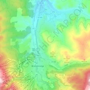
Name: Breckenridge topographic map, elevation, terrain.
Average elevation: 3,058 m
Minimum elevation: 2,802 m
Maximum elevation: 3,560 m
At the 2020 United States Census, the town had a total area of 6.047 square miles (15.661 km2), all of it land. The ski area has a total area of 2,880 acres (11.7 km2) of land. The elevation of Breckenridge is 9,600 feet (2,900 m) above sea level.
Other topographic maps
Click on a map to view its topography, its elevation and its terrain.
Frisco
United States > Colorado > Summit County
Frisco, Summit County, Colorado, United States
Average elevation: 2,835 m
Clinton Creek
United States > Colorado > Summit County
Clinton Creek, Summit County, Colorado, United States
Average elevation: 3,788 m