
Make a donation
Gear up for your next adventure:
As an Amazon Associate, this site earns from qualifying purchases at no extra cost to you.
Llanars topographic map
Click on the map to display elevation.
Make a donation
Gear up for your next adventure:
As an Amazon Associate, this site earns from qualifying purchases at no extra cost to you.
About this map
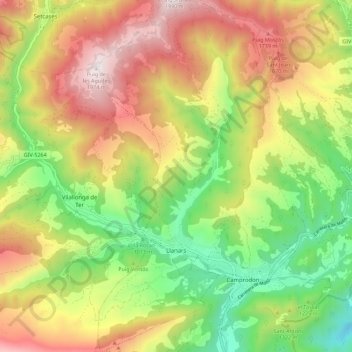
Name: Llanars topographic map, elevation, terrain.
Location: Llanars, Ripollais, Gérone, Catalogne, Espagne (42.29562 2.31841 42.37903 2.37349)
Average elevation: 1,327 m
Minimum elevation: 777 m
Maximum elevation: 1,973 m
Make a donation
Gear up for your next adventure:
As an Amazon Associate, this site earns from qualifying purchases at no extra cost to you.
Other topographic maps
Click on a map to view its topography, its elevation and its terrain.
Font del Fra Joan
Espagne > Catalogne > Ripollais > Setcases > Cabanes de la Serra
Average elevation: 2,084 m
Make a donation
Gear up for your next adventure:
As an Amazon Associate, this site earns from qualifying purchases at no extra cost to you.