Geolocate

Chablis topographic map

Click on the map to display elevation.

About this map
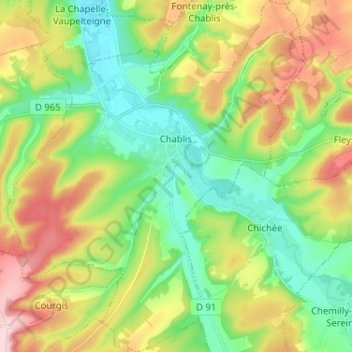
Name: Chablis topographic map, elevation, terrain.

Location: Chablis, Auxerre, Yonne, Bourgogne – Franche-Comté, Metropolitan France, 89800, France (47.76262 3.73851 47.84915 3.84773)

Average elevation: 202 m

Minimum elevation: 123 m

Maximum elevation: 331 m

Other topographic maps

Click on a map to view its topography, its elevation and its terrain.

Sixte

France > Bourgogne – Franche-Comté > Yonne > Michery

Average elevation: 70 m

Anus

France > Bourgogne – Franche-Comté > Yonne > Fouronnes

Average elevation: 231 m

L'Ormeau

France > Bourgogne – Franche-Comté > Yonne > Vaudeurs

Average elevation: 215 m

Bapaume

France > Bourgogne – Franche-Comté > Yonne > Dollot

Average elevation: 149 m

Crai

France > Bourgogne – Franche-Comté > Yonne > Chamoux

Average elevation: 246 m

Gear up for your next adventure:

🧢Sun Hat - Wide-brim hat for sun protection
🧣Merino Neck Gaiter - Protects against wind, sun, and cold at high altitudes
🧥Thermal Fleece Jacket - Versatile insulation for changing mountain temperatures
🦶Anti-Blister Balm - Prevents friction and hotspots during long ascents
🥾Trekking Poles - Adjustable trekking poles to reduce knee stress and improve stability

As an Amazon Associate, this site earns from qualifying purchases at no extra cost to you.