Geolocate

Enter topographic map

Click on the map to display elevation.

About this map

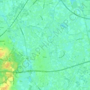
Name: Enter topographic map, elevation, terrain.

Location: Enter, Wierden, Overijssel, Netherlands (52.26912 6.54509 52.34017 6.63178)

Average elevation: 12 m

Minimum elevation: 6 m

Maximum elevation: 33 m

Gear up for your next adventure:

🧭GPS Handheld Device - Reliable GPS navigation for outdoor adventures
🔦LED Headtorch - Bright and durable light for night activities
🧴Insect Repellent - Protect yourself from bugs during outdoor adventures
🧊Portable Cooler - Keep food and drinks cold during outdoor adventures
🧭GPS Outdoor Watch - Smart watch for navigation and fitness tracking in nature

As an Amazon Associate, this site earns from qualifying purchases at no extra cost to you.