
Make a donation
Gear up for your next adventure:
As an Amazon Associate, this site earns from qualifying purchases at no extra cost to you.
Wanaque topographic map
Click on the map to display elevation.
Make a donation
Gear up for your next adventure:
As an Amazon Associate, this site earns from qualifying purchases at no extra cost to you.
About this map
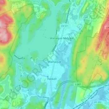
Name: Wanaque topographic map, elevation, terrain.
Location: Wanaque, Passaic County, New Jersey, United States (41.01140 -74.32437 41.07293 -74.25060)
Average elevation: 125 m
Minimum elevation: 60 m
Maximum elevation: 328 m
Make a donation
Gear up for your next adventure:
As an Amazon Associate, this site earns from qualifying purchases at no extra cost to you.
Other topographic maps
Click on a map to view its topography, its elevation and its terrain.
Bearfort Mountain
United States > New Jersey > Passaic County > West Milford
At an elevation of 1,331 feet (406 m) the ridge is the site of a 68 feet (21 m) high fire lookout tower built by the New Jersey Forest Fire Service.
Average elevation: 354 m
Make a donation
Gear up for your next adventure:
As an Amazon Associate, this site earns from qualifying purchases at no extra cost to you.
Make a donation
Gear up for your next adventure:
As an Amazon Associate, this site earns from qualifying purchases at no extra cost to you.
Cupsaw Lake
United States > New Jersey > Passaic County > Ringwood > Erskine Lakes
Average elevation: 157 m
Upper Greenwood Lake
United States > New Jersey > Passaic County > West Milford
Average elevation: 360 m
Make a donation
Gear up for your next adventure:
As an Amazon Associate, this site earns from qualifying purchases at no extra cost to you.
Township of Wayne McCoog Park
United States > New Jersey > Passaic County > Wayne
Average elevation: 55 m
Make a donation
Gear up for your next adventure:
As an Amazon Associate, this site earns from qualifying purchases at no extra cost to you.