Geolocate

Martel topographic map

Click on the map to display elevation.

About this map
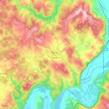
Name: Martel topographic map, elevation, terrain.

Location: Martel, Gourdon, Lot, Occitania, Metropolitan France, 46600, France (44.89527 1.55446 44.97670 1.65347)

Average elevation: 219 m

Minimum elevation: 102 m

Maximum elevation: 335 m

Other topographic maps

Click on a map to view its topography, its elevation and its terrain.
Lostange

France > Occitania > Lot > Linac

Average elevation: 326 m

Mas de la croix

France > Occitania > Lot > Béduer

Average elevation: 283 m

Pech de Fos

France > Occitania > Lot > Cieurac

Average elevation: 247 m

Gear up for your next adventure:

🔨Vehicle Emergency Tool - Safety tool for remote road trips to trailheads
📷Outdoor Action Camera - Capture high-elevation views and rugged adventures
🩹Moleskin Blister Pads - Direct protection for painful foot pressure points
🧢Hiking Sun Hat - Wide-brimmed protection for exposed mountain ridges
🛰️Satellite Messenger - Emergency communication for areas with no cell service

As an Amazon Associate, this site earns from qualifying purchases at no extra cost to you.