Geolocate

Sambungan topographic map

Click on the map to display elevation.

About this map

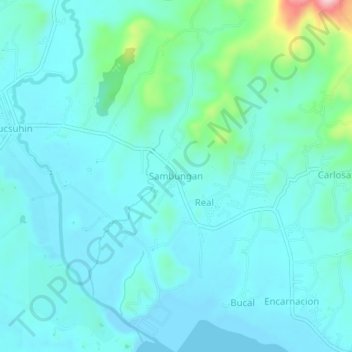
Name: Sambungan topographic map, elevation, terrain.

Location: Sambungan, Calatagan, Batangas, Calabarzon, Philippines (13.85590 120.64072 13.89590 120.68072)

Average elevation: 37 m

Minimum elevation: -4 m

Maximum elevation: 241 m

Other topographic maps

Click on a map to view its topography, its elevation and its terrain.

Burot Beach

Philippines > Batangas > Calatagan

Average elevation: 3 m

Pagapas Bay

Philippines > Batangas > Calatagan

Average elevation: 15 m

Gear up for your next adventure:

🏃Hydration Running Vest - Carry water and maps close to your body for speed
🧥Softshell Hiking Jacket - The perfect balance of wind protection and breathability
🩹Compact First Aid Kit - Pre-packed essentials for common trail injuries
🧰Survival Kit - Essential gear for emergencies in the wilderness
🥾Hiking Shorts - Breathable shorts suitable for summer hikes

As an Amazon Associate, this site earns from qualifying purchases at no extra cost to you.