Geolocate

Santa Elena topographic map

Click on the map to display elevation.

About this map

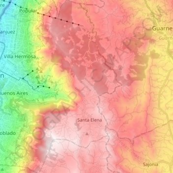
Name: Santa Elena topographic map, elevation, terrain.

Location: Santa Elena, Medellín, Valle de Aburrá, Antioquia, RAP del Agua y la Montaña, 050017, Colombia (6.17019 -75.55726 6.30121 -75.47364)

Average elevation: 2,254 m

Minimum elevation: 1,442 m

Maximum elevation: 2,795 m

Other topographic maps

Click on a map to view its topography, its elevation and its terrain.

Medellín

Colombia > Antioquia > Medellín

Medellín has 16 comunas (districts), 5 corregimientos (townships), and 271 barrios (neighborhoods). The metropolitan area of Medellín lies within the Aburrá valley at an elevation of 1,500 metres (4,900 feet) above sea level and is bisected by the Medellín River (also called Porce), which flows northward.…

Average elevation: 2,098 m

Santa Elena

Colombia > Antioquia > Medellín

Average elevation: 2,547 m

Cerro El Volador

Colombia > Antioquia > Medellín

Average elevation: 1,500 m

Gear up for your next adventure:

💡LED Camping Lantern - Illuminate your campsite with long-lasting lanterns
🧦Crew Hiking Socks - Comfortable socks for long-distance hikes
📷Outdoor Action Camera - Capture high-elevation views and rugged adventures
🛰️Satellite Messenger - Emergency communication for areas with no cell service
🧢Hiking Hat - Sun-protective and breathable hats for long treks

As an Amazon Associate, this site earns from qualifying purchases at no extra cost to you.