Geolocate

Annapurna topographic map

Click on the map to display elevation.

About this map

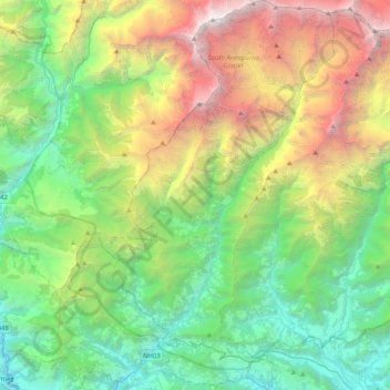
Name: Annapurna topographic map, elevation, terrain.

Location: Annapurna, Kaski, Gandaki Province, 33711, Nepal (28.25514 83.69944 28.61295 83.94755)

Average elevation: 2,974 m

Minimum elevation: 747 m

Maximum elevation: 8,013 m

Other topographic maps

Click on a map to view its topography, its elevation and its terrain.

Ghandruk

Nepal > Gandaki Province > Kaski

Average elevation: 1,897 m

Nayapul

Nepal > Gandaki Province > Kaski

Average elevation: 1,320 m

Gear up for your next adventure:

🔥Emergency Fire Starter - Reliable ignition source for all weather conditions
🧴Sunscreen SPF - Broad-spectrum sunscreen for outdoor activities
🧢Hiking Hat - Sun-protective and breathable hats for long treks
📷Outdoor Action Camera - Capture high-elevation views and rugged adventures
🦯Trekking Poles - Reduced impact on joints for steep topographic climbs

As an Amazon Associate, this site earns from qualifying purchases at no extra cost to you.