Geolocate

Laxe topographic map

Click on the map to display elevation.

About this map
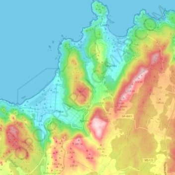
Name: Laxe topographic map, elevation, terrain.

Location: Laxe, Bergantiños, A Coruña, Galicia, Spain (43.15116 -9.07807 43.23345 -8.97202)

Average elevation: 112 m

Minimum elevation: -1 m

Maximum elevation: 333 m

Other topographic maps

Click on a map to view its topography, its elevation and its terrain.
Cercido

Spain > Galicia > Bergantiños

Average elevation: 300 m

Moucos

Spain > Galicia > Bergantiños

Average elevation: 361 m

A Laracha

Spain > Galicia > Bergantiños

Average elevation: 186 m

Nebrexe

Spain > Galicia > Bergantiños

Average elevation: 347 m

As Brañas

Spain > Galicia > Bergantiños > A Laracha

Average elevation: 176 m

Gear up for your next adventure:

💡Portable Camping Lamp - Rechargeable lamp for campsite lighting
⛺Family Camping Tent - Spacious tent suitable for family camping trips
⛺Camping Tent - Weather-resistant tents suitable for 2 to 6 people
🎒Fully Waterproof Backpack - Total protection for photography gear and electronics
🥤Collapsible Travel Cup - Saves space and weight in your mess kit

As an Amazon Associate, this site earns from qualifying purchases at no extra cost to you.