
Make a donation
Gear up for your next adventure:
As an Amazon Associate, this site earns from qualifying purchases at no extra cost to you.
Foz do Iguaçu topographic map
Click on the map to display elevation.
Make a donation
Gear up for your next adventure:
As an Amazon Associate, this site earns from qualifying purchases at no extra cost to you.
About this map
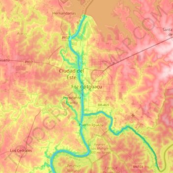
Name: Foz do Iguaçu topographic map, elevation, terrain.
Average elevation: 214 m
Minimum elevation: 88 m
Maximum elevation: 309 m
Make a donation
Gear up for your next adventure:
As an Amazon Associate, this site earns from qualifying purchases at no extra cost to you.
Other topographic maps
Click on a map to view its topography, its elevation and its terrain.
Itaipu Dam
Brazil > Paraná > Foz do Iguaçu
325 metres (1,066 ft), entire dam including the 100 metres (330 ft) high Power Line 4 Pylons atop the Barrage 260 metres (850 ft), dam + the foundation inside water until the river floor 247 metres (810 ft), 196 metres (643 ft) high of roof reinforcement concrete dam + Cranes atop the Barrage 225 metres (738…
Average elevation: 192 m