
Make a donation
Gear up for your next adventure:
As an Amazon Associate, this site earns from qualifying purchases at no extra cost to you.
Xerta topographic map
Click on the map to display elevation.
Make a donation
Gear up for your next adventure:
As an Amazon Associate, this site earns from qualifying purchases at no extra cost to you.
Xerta
Xerta liegt etwa 59 Kilometer westsüdwestlich von Tarragona in einer durchschnittlichen Höhe von ca. 15 m nahe dem Ebro-Delta und am Golf de Sant Jordi (Mittelmeer). Der Ebro begrenzt die Gemeinde im Osten.
Make a donation
Gear up for your next adventure:
As an Amazon Associate, this site earns from qualifying purchases at no extra cost to you.
About this map
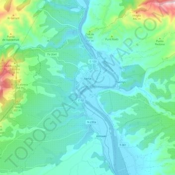
Name: Xerta topographic map, elevation, terrain.
Location: Xerta, Baix Ebre, Tarragona, Katalonien, 43592, Spanien (40.86112 0.41661 40.94613 0.50979)
Average elevation: 125 m
Minimum elevation: 2 m
Maximum elevation: 624 m
Make a donation
Gear up for your next adventure:
As an Amazon Associate, this site earns from qualifying purchases at no extra cost to you.
Other topographic maps
Click on a map to view its topography, its elevation and its terrain.