Geolocate

Calamar topographic map

Click on the map to display elevation.

About this map

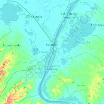
Name: Calamar topographic map, elevation, terrain.

Location: Calamar, Dique, Bolívar, RAP Caribe, Colombia (10.10150 -75.09267 10.36617 -74.90781)

Average elevation: 26 m

Minimum elevation: 1 m

Maximum elevation: 231 m

Other topographic maps

Click on a map to view its topography, its elevation and its terrain.

Galerazamba

Colombia > Bolívar > Santa Catalina

Average elevation: 5 m

Ancon

Colombia > Bolívar > Santa Cruz de Mompóx

Average elevation: 18 m

Gear up for your next adventure:

👟Sport Hiking Sandals - Breathable footwear for water crossings and camp rest
💡LED Headlamp - Hands-free illumination for night hiking and camping
🧶550 Survival Paracord - Versatile utility cord for emergency repairs and rigging
🧼Biodegradable Camp Soap - Environmentally friendly cleaning for gear and body
🛶Waterproof Dry Bags - Keep electronics and clothes dry during river crossings

As an Amazon Associate, this site earns from qualifying purchases at no extra cost to you.