
Make a donation
Gear up for your next adventure:
As an Amazon Associate, this site earns from qualifying purchases at no extra cost to you.
Saipan topographic map
Click on the map to display elevation.
Make a donation
Gear up for your next adventure:
As an Amazon Associate, this site earns from qualifying purchases at no extra cost to you.
Saipan
Saipan, the largest island in the Northern Mariana Islands, features a diverse and rugged topography shaped by volcanic activity. The island's central region is dominated by Mount Tapochau, its highest peak at 1,553 feet (474 meters), providing a dramatic backdrop to the surrounding landscape. This volcanic terrain is primarily composed of andesitic and dacitic rocks, formed from the island’s volcanic origins. The eastern coastline is characterized by steep cliffs and rugged hills, while the western side presents more gradual slopes leading to coral reefs and sandy beaches. Saipan's geography is also marked by extensive limestone plateaus, particularly in the southern areas, and lush valleys with tropical vegetation. These varied landforms contribute to the island's distinctive natural beauty and its importance as a key location in the Pacific.
Make a donation
Gear up for your next adventure:
As an Amazon Associate, this site earns from qualifying purchases at no extra cost to you.
About this map
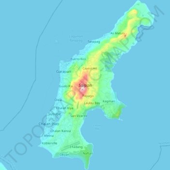
Name: Saipan topographic map, elevation, terrain.
Average elevation: 22 m
Minimum elevation: 0 m
Maximum elevation: 462 m
Make a donation
Gear up for your next adventure:
As an Amazon Associate, this site earns from qualifying purchases at no extra cost to you.