
Make a donation
Gear up for your next adventure:
As an Amazon Associate, this site earns from qualifying purchases at no extra cost to you.
Sunlight Lake topographic map
Click on the map to display elevation.
Make a donation
Gear up for your next adventure:
As an Amazon Associate, this site earns from qualifying purchases at no extra cost to you.
About this map
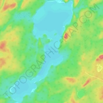
Name: Sunlight Lake topographic map, elevation, terrain.
Average elevation: 374 m
Minimum elevation: 352 m
Maximum elevation: 419 m
Make a donation
Gear up for your next adventure:
As an Amazon Associate, this site earns from qualifying purchases at no extra cost to you.
Other topographic maps
Click on a map to view its topography, its elevation and its terrain.
Slate Islands
Canada > Ontario > Kenora District > Unorganized Kenora District
Average elevation: 322 m
Loveland Lake
Canada > Ontario > Kenora District > Unorganized Kenora District
Average elevation: 426 m
Galbraith Lake
Canada > Ontario > Kenora District > Unorganized Kenora District
Average elevation: 455 m
Make a donation
Gear up for your next adventure:
As an Amazon Associate, this site earns from qualifying purchases at no extra cost to you.
Banana Island
Canada > Ontario > Kenora District > Unorganized Kenora District
Average elevation: 359 m
Ghost Island
Canada > Ontario > Kenora District > Unorganized Kenora District
Average elevation: 401 m
Make a donation
Gear up for your next adventure:
As an Amazon Associate, this site earns from qualifying purchases at no extra cost to you.