Geolocate

Inaclagan topographic map

Click on the map to display elevation.

About this map

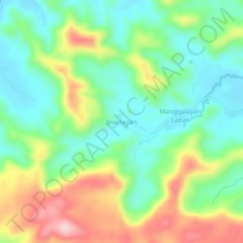
Name: Inaclagan topographic map, elevation, terrain.

Location: Inaclagan, Quezon, Calabarzon, 4331, Philippines (13.94747 121.89414 13.98747 121.93414)

Average elevation: 99 m

Minimum elevation: 8 m

Maximum elevation: 260 m

Gear up for your next adventure:

🔦UV Flashlight - Detect minerals or specific insects in the dark
🥫Freeze-Dried Meals - Lightweight, high-calorie nutrition for multi-day treks
🧢Outdoor Visor - Breathable visor for sunny hikes
🧭GPS Tracker - Track your location in remote areas safely
🥾Hiking Boots - Sturdy boots providing ankle support and traction on rugged trails

As an Amazon Associate, this site earns from qualifying purchases at no extra cost to you.