Geolocate

Clifton topographic map

Click on the map to display elevation.

About this map

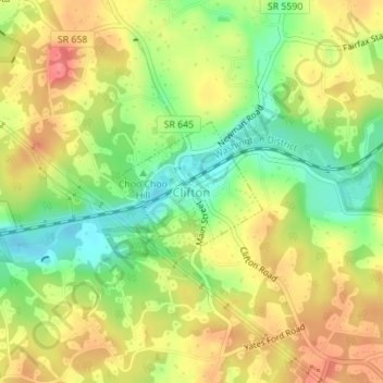
Name: Clifton topographic map, elevation, terrain.

Location: Clifton, Fairfax County, Virginia, United States (38.77528 -77.39290 38.78517 -77.38023)

Average elevation: 87 m

Minimum elevation: 50 m

Maximum elevation: 121 m

Gear up for your next adventure:

🦌Outdoor Trail Camera - Monitor wildlife activity near your favorite spots
🥾Mountain Hiking Shoes - Shoes with superior grip for mountainous terrain
🎒Hiking Daypack - Lightweight and durable backpacks for day trips and excursions
🧢Sun Protection Cap - Breathable cap to protect from sun exposure
🚲Handlebar Phone Mount - View topographic-map.com live while cycling

As an Amazon Associate, this site earns from qualifying purchases at no extra cost to you.